How the land was acquired
The area of today’s park was the immediate grounds of St Mary’s Abbey, including fishponds, a lake, vineyard and orchards. After the Abbey’s destruction, the ownership of the land eventually fell to Thomas Villiers in 1753, later the first Earl of Clarendon of the second creation, and from that point continued with the Earldom.
Although the fields were let for grazing livestock, successive Clarendons also allowed them to be used for events; they were perfectly located between the two parts of the town and thus accessible to all. Events included the celebrations of Queen Victoria’s visit to the town, cricket matches, ice skating, and fire brigade demonstrations.
In 1842 and 1867, small parts of the fields were taken for extending the St Nicholas churchyard; another extension was needed in 1881 but Clarendon refused, and then in late 1882 he put the whole estate, which included Little Virginia, up for sale for £16,000 in one plot as building land. The Local Board of Health (the Town Council of the day) saw their chance to buy the land so they could extend the churchyard, provide a permanent recreation ground, build the oft-called for swimming pool, and stop the building development going ahead.
What followed was a long and complex series of transactions and deals; full details and original documents can be found in The Abbey Fields, but the following is a simplified version.
The Local Board had intended to buy the whole estate, but legal restrictions meant they could not raise sufficient cash. Fearing the worst, a group of preservationists, numbering at least 18, that lived along Abbey Hill and Rosemary Hill raised enough money to purchase the 13 acres that their properties overlooked. Local Board member William Evans then put together a scheme whereby the Board could buy just the central 40 acres and repay the loans by continuing to rent out the fields for grazing. Evans then formed a syndicate to buy the rest of the fields around the perimeter and to sell from them as many building plots as needed to recoup their outlay. The sale by Clarendon to the three factions went ahead on 12th May 1884. This split the land as follows:
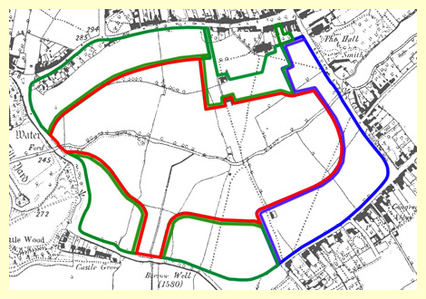 |
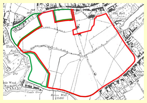
1) The plots as bought from Clarendon in 1884. The Local Board bought the red area for their park; the blue area was bought by the Preservationists to keep their views, and the green areas were those bought by the syndicate to sell some as building plots. (NOTE: In all these graphics, the area open as a park is shown in red) |
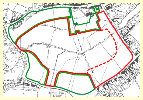 |
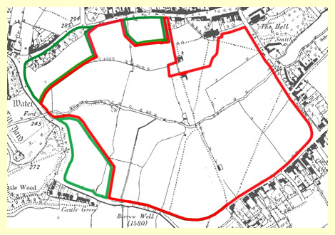
2) Six Months later on 28th November 1884, the preservationists conveyed their area of land to the St Nicholas churchwardens for safe keeping, but allowed the Board to use the area as part of their park. |
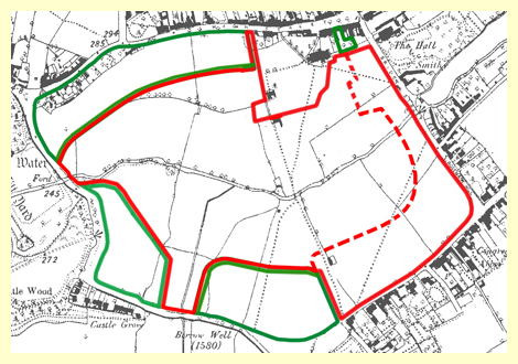 |
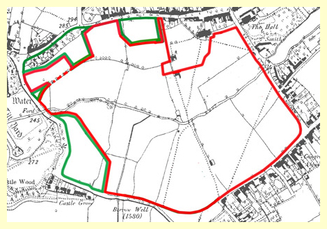
4) In 1912 a small land exchange took place with the owner of The Bungalow in Castle Road, slightly altering the shape of the park once more and adding 487 square yards to it. |
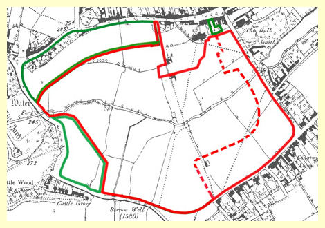 |
5) The Syndicate’s area alongside Forrest Road became owned by Gertrude Evans, the daughter of William Evans who organised the purchase of the fields and set up the syndicate. After her last close family member, her brother, died in 1917, during a time of goodwill to all Gertrude donated the land to be added to the park. |
 |
At some time, thought to be in the 1930s, the churchwardens land was taken over by the Kenilworth Urban District Council and added to the park.
6) Gertrude Evans had lived in Clinton House in High Street and owned the building plots opposite so as to preserve her view. Now living in Dorset, on 22nd October 1938 she donated those plots to be added to the park. |
 |
7) As the end of the KUDC to be replaced by the new Warwick District Council approached in 1974, there were two further additions to the park. Firstly, Councillor Whiteman gave a corner of his garden ground in High Street…….. |
 |
8) ….and then the KUDC bought an area behind Little Virginia which became known as The Paddock.
This brought to an end the land acquisition, but there has also been some land lost, notably alongside Rosemary Hill and Abbey Hill for road widening schemes. |
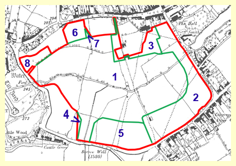
And so the Abbey Fields is made up of 8 individual plots as shown here (the numbers corresponding to the above paragraphs):
The maps are for reference only; the plots are not exactly to scale. The actual plans taken from the deeds and many more details can be seen in my book, The Abbey Fields.
More Abbey fields articles:
The Covenants Each plot came with a covenant and restrictions
Abbey Fields Cycle Path Always under discussion, a complete record of attempts for cycling to return to the park
The Swimming Pool The history of the pool from its origins in the 1890s until the present day, with a number of photographs
Car Parking in the Abbey Fields How the car park came about
Bye-laws The non-observance of bye-laws is often discussed, here you can see them all
Abbey Fields Archaeology A guide to the many archaeological explorations of the Abbey and its surroundings from 1840 to the present day
Abbey Fields Play Equipment Some aspects of the park play equipment, now established over a century
Abbey Fields, 1947 A look at the park as it appeared in the national aerial record of 1947
Abbey Fields Timeline A chronology of the Abbey Fields starting in the ice age!
Return to Abbey Fields home page
See also my book: